Loop 101 trunk relocation near Pima interchange
ADOT MOT and night drilling windows — permit lead exceeds bore duration; alignment engineered before bid.
Scottsdale, AZ · Maricopa County
Scottsdale highway, canal, and wash crossings on Loop 101, Arizona Canal, and Indian Bend — long-span HDD and casing when open cut fails ADOT, SRP, and flood-control review.
River, highway, and canal crossings in Scottsdale are where trenchless stops being optional — ADOT relocations on Loop 101, SRP Arizona Canal paths, and Indian Bend Wash alignments rarely justify open cut against engineered bore plans when greenbelt and resort frontage are in play.
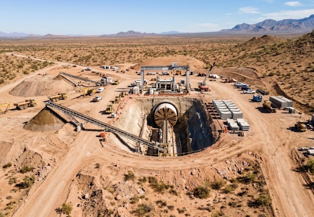
Directional boring in Scottsdale at crossing scale means larger spreads, staged reaming, pullback monitoring, and agency calendars that start months before drill day. Traffic control, night MOT, and SRP irrigation windows set the schedule more often than rig availability.
Municipal water and sewer trunks, telecom backbones, and resort-scale electric feeders share corridor headaches — multiple utilities in one casing require engineered dividers and maintenance access, not ad hoc bundling.
Real Maricopa County angles — not generic statewide copy.
ADOT MOT and night drilling windows — permit lead exceeds bore duration; alignment engineered before bid.
SRP irrigation district and bank stability review — HDD or jack-and-bore profile avoids open cut through easement fill.
Flood-control review — engineered profile avoids open cut through greenbelt alluvium and trail systems.
City permits and franchise alignment — long shot with staged ream and survey closeout.
Scottsdale crossing work begins with engineered profile and controlling permit identification — ADOT, SRP, or flood authority leads notification beyond standard 811. Larger rigs mobilize with mud plants and pullback monitoring; inspection milestones follow agency documents. As-built survey delivers before final landscape restoration.
Scottsdale mixes McDowell foothill decomposed granite, valley caliche, and Arizona Canal alluvium — north Scottsdale cobble and boulder fields slow pilots without matched mud programs.
Most Scottsdale bores hit caliche crust between 2 and 8 feet, then alluvial sand or decomposed granite depending on distance from the McDowells. North Scottsdale and Troon shots add mountain fan cobble and boulder fields that slow penetration without correct tooling. Greenbelt-adjacent parcels carry sandy fill with seasonal groundwater after monsoon storms — buoyancy management matters on long HDPE pulls. We size ream stages for Scottsdale geology, not a generic Phoenix valley template.
Sonoran heat, north-valley wind, and monsoon outflows shape Scottsdale bore schedules — Indian Bend Wash sheet flow and afternoon lightning holds are planned into quotes.
Monsoon season from July through September softens greenbelt-adjacent ROW and can delay entry pits on sandy fill. Spring wind on exposed north Scottsdale pads affects cage and fluid handling along Shea and Pima. Summer heat above 110°F slows morning startup on exposed sites but rarely stops work — we communicate when dry conditions matter for granite-heavy pits rather than risk frac-outs toward the Indian Bend Wash.
City of Scottsdale Development Services, Maricopa County ROW, ADOT District, SRP Arizona Canal easements, and tribal-community coordination apply on many alignments.
Inside Scottsdale city limits, street cuts, driveway removals, and greenbelt-adjacent work may need Development Services permits. Maricopa County ROW rules apply on unincorporated pockets toward north Scottsdale. ADOT controls Loop 101 and state highway bores — expect traffic control plans and sometimes night-only windows on resort frontage. SRP Arizona Canal easements add coordination beyond standard 811. HOA and resort properties may add landscape bond and restoration review on pit placement.
Major Scottsdale crossings rarely justify open cut — detour cost, canal and greenbelt impact, and lane closure math favor trenchless once alignment is approved. Short local street bores are a different scope than mile-class highway crossings.
Length, diameter, groundwater, environmental windows, flagging, engineering, inspection.
You share plans or describe the problem; we confirm alignment, depth, access, and which trenchless method fits Arizona soils.
Arizona 811 ticket filed; two business days minimum before pits open unless your permit path differs. We pothole where marks conflict.
Bore plan, ADOT or city ROW permits, railroad agreements, and crossing engineering when the path leaves private property.
Compact spread for tight Scottsdale lots; larger HDD for I-17 or Loop 101 relocations — matched to length and diameter.
Steered pilot on design line, ream passes sized for your pipe or casing, fluid program tuned for caliche or decomposed granite.
HDPE fusion, steel casing, or multi-duct bundle pulled with tension and bend-radius monitoring.
Pressure test, mandrel, or survey records for owners, inspectors, and operators as spec requires.
Compact pits, replace gravel or hardscape per scope, leave 811 ticket and locate map in your project file.
District and scope drive weeks-to-months — assume permits before drill date, not parallel to mobilization.
Possible with engineered dividers and maintenance access per owner spec — not improvised bundling.
Arizona Canal, Indian Bend Wash, and McDowell wash tributaries each carry different easement and access rules.
Yes — SRP templates with inspection and restoration standards; irrigation district agreements often set the critical path.
Length, diameter, groundwater, MOT, irrigation windows, and inspection drive price — engineered quotes only.
24/7 — Emergency dispatch statewide. Tell us entry, exit, pipe size, and county — a bore specialist calls back with cost drivers, not a flat rate.
Scope your alignment
Step 1 of 2 — path, pipe, and city first